This webpage presents an interactive map that accompanies our "Skilled Immigrants and Technology Adoption" paper published in Explorations in Economic History in July 2021. The map overlays the figures reported in the paper with additional historical data and the Google basemap, enabling readers to customize the map's content and zoom in on different regions. The pop-up windows that appear after clicking on the polygons show the exact numbers used in coloring the map.
Below, I provide details on the data sources and references to additional literature, inviting readers to engage more thoroughly with the history of the Saratov Germans.
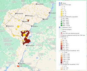
The map shows the historical borders of the townships (volost) and districts (uezd) of Saratov province in the Russian Empire. The township borders correspond to 1913 and have been digitized from the List of Settlements of Saratov Province published by the Saratov provincial zemstvo. The data on the location of railroads, rural fairs, and German settlements come from the same source.
The layers showing (a) the share of Germans in the township population in 1897, (b) the number of iron ploughs and (c) fanning mills per household in 1913, and (d) the share of households engaged in craftsmanship in 1917 rely on township-level data. The population density in 1763, on the eve of the German immigration to the Russian Empire, has been measured at the district level. Yellow dots mark the location of villages that held a rural fair in 1913. Since all of these layers appear in the paper, you can find the data sources and the discussion of measurement issues there.
The interactive map also contains three additional layers not reported in the paper. Two layers visualize the area designated for foreign settlement by the 1764 Law (Law #12095 in the Complete Collection of Laws of the Russian Empire). Red diamonds represent the reference points explicitely mentioned in the law:
"...from Chardym Island to Tsaritsyn, from Tsaritsyn to the Don fortress, and futher to the unnamed river that flows into the Don, and then to the Medveditsa River and further to the Khoper River, and from the Khoper up the Don River to the Bityug River, and then following the Bityug to its source, and from the source of the Bityug River to Novokhoperskaya, and from there up the Khoper River to the villages of Znamenskoye and Dolgorukovo, and then following the Penza border to Saratov District, and then crossing Saratov District by smaller rivers back to Chardym Island."
The 1764 Law mentions the map of the suggested area; however, the Complete Collection of Laws does not contain it. It may have been lost or still exist in the archives, but we could not identify its location. The red polygon reconstructs the settlement area by connecting the diamonds, either by straight lines or by rivers, whenever it is explicitly indicated by the Law. The resulting polygon covers an area of 261,106 square kilometers. As reported by Jacob Dietz, an Imperial historian of the Volga Germans, although the Russian government deemed the area specified in the 1764 Law as vacant, it has been in fact granted to the noble Naryshkin family. As a result, the actual German settlement area in Saratov Province, denoted by the thick green line, covered only 7,334 square kilometers. (The Imperial authorities also settled Germans on the right bank of the Volga River in Samara Province, outside of the designated settlement area; we focused on Saratov Province only because detailed data on technology adoption were unavailable for Samara Province.)
Another layer, not reported in the paper, shows the location of 58 German settlements in Saratov Province — or colonies, as they were known in the official language of the Russian Empire, marked by green dots. Since the scale of this layer is more fine-grained, I recommend zooming in on the German settlement area and turning off the rural fairs layer. The size of the dots corresponds to the settlement population in 1913. Clicking on the dots will also provide information on the year when the settlement was established.
The German settlements constituted a thriving world before and after the Russian Revolution. For example, in 1913, Norka (Weigand), the largest Saratov colony, had more residents than the district cities of Atkarsk or Serdobsk. However, this world encountered an abrupt and tragic end in 1941, when Soviet authorities deported the German population of the Volga region, including the Saratov Germans, to Central Asia. The deportees were forced to leave behind their houses, factories, mills, and churches, which have been decaying ever since. The Volga Germans were not allowed to come home up until the collapse of the Soviet Union; afterward, most of them moved to Germany. According to the 2010 Russian Census, only 18 thousand Germans now live in Saratov and Volgograd regions, as opposed to 166 thousand Saratov Germans in 1897.
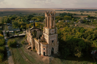
The ruins of St. Mary's Catholic Church in Kamenka (Bähr)
Source: Instagram: @13_pilot (perito.)
References
Dietz, Jacob E. (2005) History of the Volga German Colonists. American Historical Society of Germans from Russia, 462 pp. (In Russian: История поволжских немцев-колонистов, written in 1917, published in 1997).
Miho, Antonela and Jarotschkin, Alexandra and Zhuravskaya, Ekaterina. (2024) Diffusion of Gender Norms: Evidence from Stalin's Ethnic Deportation. Journal of the European Economic Association, Volume 22, Issue 2, April 2024, Pages 475–527.